It’s essentially an open source fork of maps.me by the original creators.
I’ve been using OSMAnd for years, but it always felt laggy and not that reliable. Searching was slow and so on. Many street or things it didn’t instantly find.
In the Graphene App Store I jnust discovered Accrescent (another app store thing but only with like 10 apps - they’re all gold though, god damn)
An in there I found organic maps. And this shit is google maps level responsive. If you’re on the lookout for a google maps replacement - consider trying this.
Byeeee
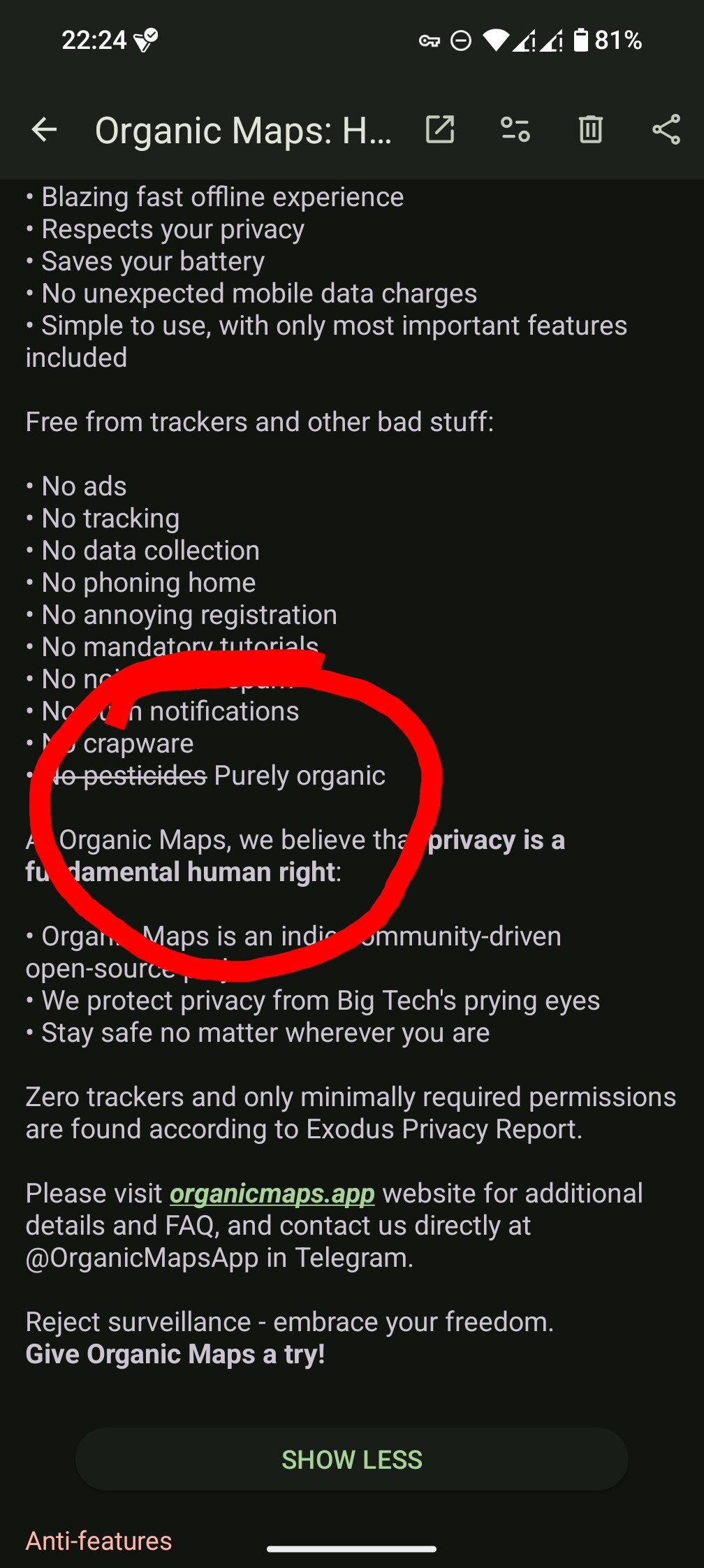
Idk … In their description on f-droid they crossed out “no pesticides” and wrote “purely organic” … It implies they are using organic pesticides. Not sure if that’s something for me tbh.
Edit: screenshot added

Caffeine and nicotine are legit organic insecticides, that might be a deeper joke about coffee and cigarettes powering development
Great point of view
Exactly …
It is pretty solid. It lacks some advanced features such as routing around preset areas but that’s a minor complaint.
Aldo it is only as good as OSM. Get to work on the map.
Also the search doesn’t work, so there is that…
Also using it in android auto is a pain and every action takes between 10x and 100x longer than on the phone.
But yeah it is pretty good and I try to contribute to it when I can. I don’t know how to contribute to bad instruction translations though. It just says “verlaat” on an exit in dutch which grammatically makes no sense.
You should open an issue
Ok downloaded. Seems very nice!
Still working out how to get directions but all things in good time.
Astronomical Clock in Prague is like a fucking wormhole for humans. Last time I was there it felt there was like a thousand people in one small place.
my wife forced me to get up really early to look at it without coffee so I wasn’t quite as whelmed as I should’ve been. Prague is lovely though.
Does it know how to navigate NYC public transit? That’s a big use case for me. I don’t need driving directions. I need to know which subway is closest.
Organic Maps is my goto solution for car navigation because it is very quick, responsive and does not require an high end phone. It just works. However for anything more advanced than that (e.g. live location sharing or recording, planning a hiking trip, navigating mountain bike trails, contributing to OpenStreemMap), OSMAnd is still without contender.
For me, it’s even better than GMaps, because it lets me navigate on bike paths, which GMaps couldn’t.
I’ve used organic for several hikes. What was missing?
Here a a few things that I miss from OsmAnd:
- adding more than a handful of routing points is tedious
- you cannot plan partially or fully independent from existing roads
- no way to save and restore a planned trip
- no overlays for hill shading or incline visualization. Very useful for assessing the effort of a route.
- no public transport support. Very useful for planning a trip with transitions.
- no rain radar
- satellite view
Thanks for the share, had no idea. It felt so nice that I already added two contributions to OpenStreetMap.
Welcome! I also added a few
Wow that genuinely looks unbelievable!
It’s like an old mall or whatever map except without you are here and movable!
What until you discover OSM (that’s what Organic maps uses)
It’s also improving really fast. Organic Maps has a great community of developers.
Does it do navigation with routes based on current traffic conditions? Because that’s table stakes to me.
No, unfortunately. But maybe soon. I lean on here maps if I need that.
Oh :( pretty useless for driving then
It’ll at least give you good directions, car/bicycle/walking-optimized based on what you select.
It’ll get there, just needs time.
I mean great if it gets there but in the meantime I’m not going to recommend it to anyone as a google maps replacement. It does look like a good maps.me replacement for hiking though!
I wouldn’t have said it was a replacement just yet to non -open source centric folks, personally.
More attention isn’t a bad thing though, sometimes devs need more input to decide what to focus on next.
It is nice app but the problem is it doesn’t show Czech hiking and cycling routes by default. I didn’t figured out how to enable them.
Yep, the best of the best :)
Too bad OSM (and by extension this app) doesn’t have public transport directions…
Word. That’s one of the things where osm gets smashed by this app
Try oeffi, it’s a great app for public transport.
Doesn’t support my city :(
It’s my go to! Also check out the !open_street_maps@lemmy.world community
Edit: sorry, it looks like the more active community is !openstreetmap@lemmy.ml but I guess you can join both lol!
Thanks!
Welcome : )


